


All projects
Drone · Aerial Survey
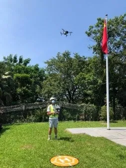
Unmanned Aerial Survey Services to various Buildings & Structures
CAD-licensed drone surveys across multiple buildings and structures — high-resolution photogrammetric capture without scaffolding.
Pilots
CAD-licensed
Capture
Photogrammetric
Disruption
No scaffolding
Project notes
Scope & approach
Including Building and Structures of Government and Private sectors
To prepare operation manual, flight plan and statutory submission for Civil Aviation Department UAS operation permit.
To carry out aerial surveys by licensed pilot to take aerial imaging, aerial video and thermal imaging etc.
To prepare aerial survey reports with necessary analysis to assess the condition of building and structures.
Gallery
Project photos
4 images on file. Click any photo to view full size.
Similar project?
Scope your building surveying or consultancy mandate
Share your asset, programme, and statutory requirements. We'll respond within 1–2 business days with a tailored proposal.